


Using remote sensing to map the areal extent and hydrologic controls on distribution of buckthorn in the Oak Openings
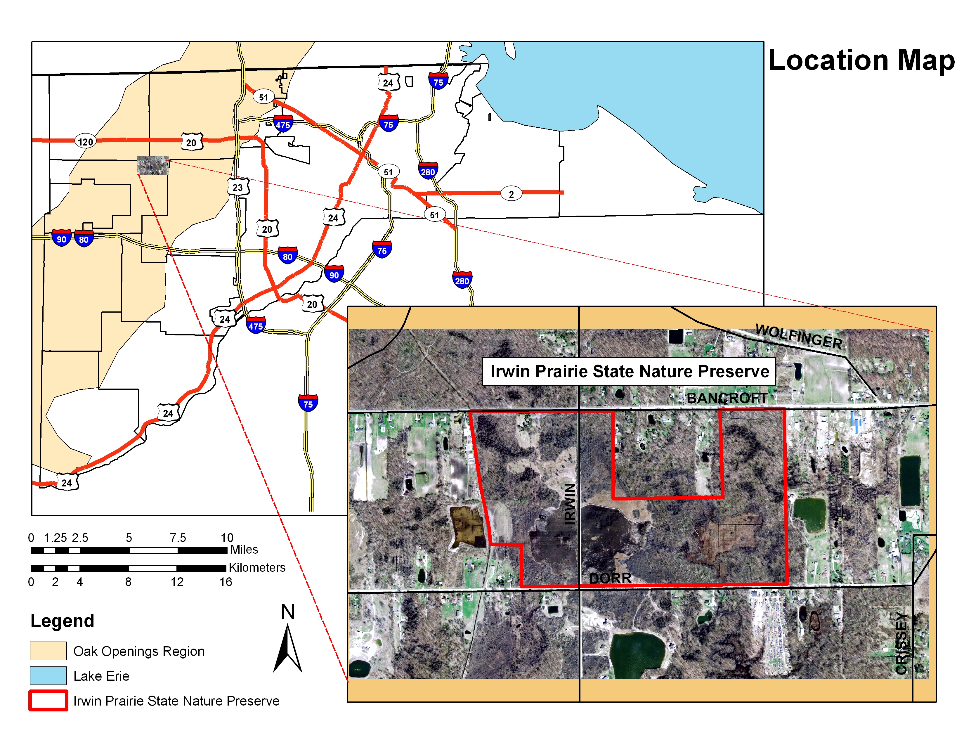
Glossy buckthorn (Frangula alnus) is a shrub of Eurasian origin first introduced to the United States in the mid 1800’s. Recently, the shrub has become an aggressive invasive pest of wetlands such as fens and bogs to the exclusion of nearly all other plant species. It has emerged as one of the greatest threats to lake plain wet prairies, such as the historic Irwin Prairie of the Oak Openings Region. The plant is known to thrive in nitrogen-rich soils and may create positive feedbacks in nitrogen cycling, thus favoring its dominance (Heneghan et al. 2006). In a GIS investigation of Irwin Prairie State Nature Preserve, the greatest extent of thicket corresponded with the lowest elevations of the site. Although the preserve’s eastern grassland (which has neither been invaded by glossy buckthorn nor received any intensive management) displays greater seasonal saturation, it sits at a higher elevation than the western portions of the preserve.
 We hypothesize that 1) the eastern grassland at
Irwin Parie is hydrologically isolated, 2) water nitrogen levels in
the eastern and western portions are significantly different and that
3) water arriving through ditched channels adjacent to the western
grasslands is promoting buckthorn thicket by nitrifying the soil.
We hypothesize that 1) the eastern grassland at
Irwin Parie is hydrologically isolated, 2) water nitrogen levels in
the eastern and western portions are significantly different and that
3) water arriving through ditched channels adjacent to the western
grasslands is promoting buckthorn thicket by nitrifying the soil.
A temporal analysis of land cover in Irwin Prarie covering 2000-2010 was conducted using LIDAR, Landsat ETM+ and air photo data to map buckthorn thicket location and extent. Differences in the phenological cycles and canopy structure of buckthorn thicket, pin oak savanna, and twig rush prairie were used to distinguish land cover.
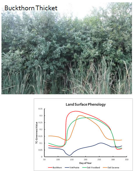
Surface drainage was modeled from LIDAR data using the TOPAZ method in a GIS environment. A locally closed surface drainage is noted due to a natural levee separating the upland surface drainage through Irwin Prarie from ten mile creek. This causes accumulation of nutrient rich runoff as surface ponding resulting in local recharge in the western grasslands area. This surface ponding is seen to coincide with the mapped buckthorn thickets in the study area.
Maps of the Buckthorn Thicket extent are avilable utilizing this kmz file, viewable in Google Earth.
Related Publication:
Becker, R.H., Zmijewski, K. A.**, Crail, T.*, 2012, Seeing the Forest for the Invasives: Mapping Buckthorn in the Oak Openings, Biological Invasions, 10.1007/s10530-012-0288-8
Selected Presentations:
Zmijewski, K.*, Becker, R.H., 2012, A bird’s eye view: tracking the progress of the invasive species Glossy Buckthorn (Rhamnus alnus) using Landsat imagery, ASPRS Annual Conference, Pasadena, CA
Zmijewski, K.**, Crail, T. and Becker, R. H., 2011, Hydrologic controls on the distributional characteristics of glossy buckthorn (frangula alnus) thicket: a study in the oak openings region of NW Ohio, Geological Society of America Abstracts with Programs, Mar 20-22, Pittsburgh, PA