Index for Downloads
Left click to view PDF files with Adobe Acrobat OR
Right click and Save As to download the file directly
Geopulse seismic data from Sinepuxent Bay -- right click and Save As to
download
SB-02d.zip
scanned.seismic.SB-02d.jpg
Pliocene Mollusk Specimens -- View images
Honeycutt
& Krantz JCR 2003 (34 MB PDF file; right click to download)
Honeycutt, M.G. and Krantz, D.E.
2003. Influence of the
geologic framework on spatial variability in long-term shoreline change, Cape
Henlopen to Rehoboth Beach, Delaware. Journal
of Coastal Research, Special Issue
38: 147-167.
Proposal to study and model the hydrology of Indian River Bay, Delaware.
Funded by NSF, June 2009. Right
click here to download the PDF file.
Report to the National Park Service to accompany the recently completed
Hydrogeomorphic Map for Assateague Island National Seashore.
Report
text (Word document)
Report
figures (PDF file)
Final draft of chapter of book on Maryland Coastal Bays (by Univ. of
Maryland)
Dynamic
Systems at the Land-Sea Interface (PDF file)
by David Krantz, Courtney Schupp, Chris Spaur,
Jane Thomas
& Darlene Wells
The book, Shifting Sands: Environmental and Cultural Change in Maryland's
Coastal Bays,
was published in June 2009 and is available for purchase at the IAN website:
http://ian.umces.edu/communication/books
Bratton et al. 2004 (PDF file)
Bratton, J.F., Böhlke, J.K., Manheim, F.T., and
Krantz, D.E. 2004.
Geochemistry
of pore fluids and discharge of submarine ground water in
Delmarva Peninsula
coastal bays. Ground Water, Oceans Issue, 42:
1021-1034.
Krantz et al. 2004
(PDF file)
Krantz, D.E., Manheim, F.T., Bratton, J.F., and Phelan, D.J.
2004.
Hydrogeologic setting and ground-water
flow beneath a section of Indian River Bay, Delaware.
Ground Water, 42: 1035-1051.
Manheim et al. 2004 (PDF file)
Manheim, F.T., Krantz, D.E., and Bratton, J.F.
2004.
Investigations
of submarine ground-water discharge in Delmarva coastal bays by horizontal
resistivity surveying and ancillary techniques.
Ground Water, 42: 1052-1068.
Assateague
Atlantic Shoreface Atlas
AI-04_05.plate.pdf
AI-04_19&20_mid.plate.pdf
If you would like a copy of the entire atlas on CD, please send a request
by email: david.krantz@utoledo.edu
Also, you may want to look at an exercise for a Stratigraphy class that I
developed
using this set of seismic
lines. It is posted as a Contributed Activity for the NSF-NAGT
workshop, Teaching Sedimentary
Geology in the 21st Century :
http://serc.carleton.edu/NAGTWorkshops/sedimentary/index.html
To go
directly to my activity:
http://serc.carleton.edu/NAGTWorkshops/sedimentary/activities/13886.html
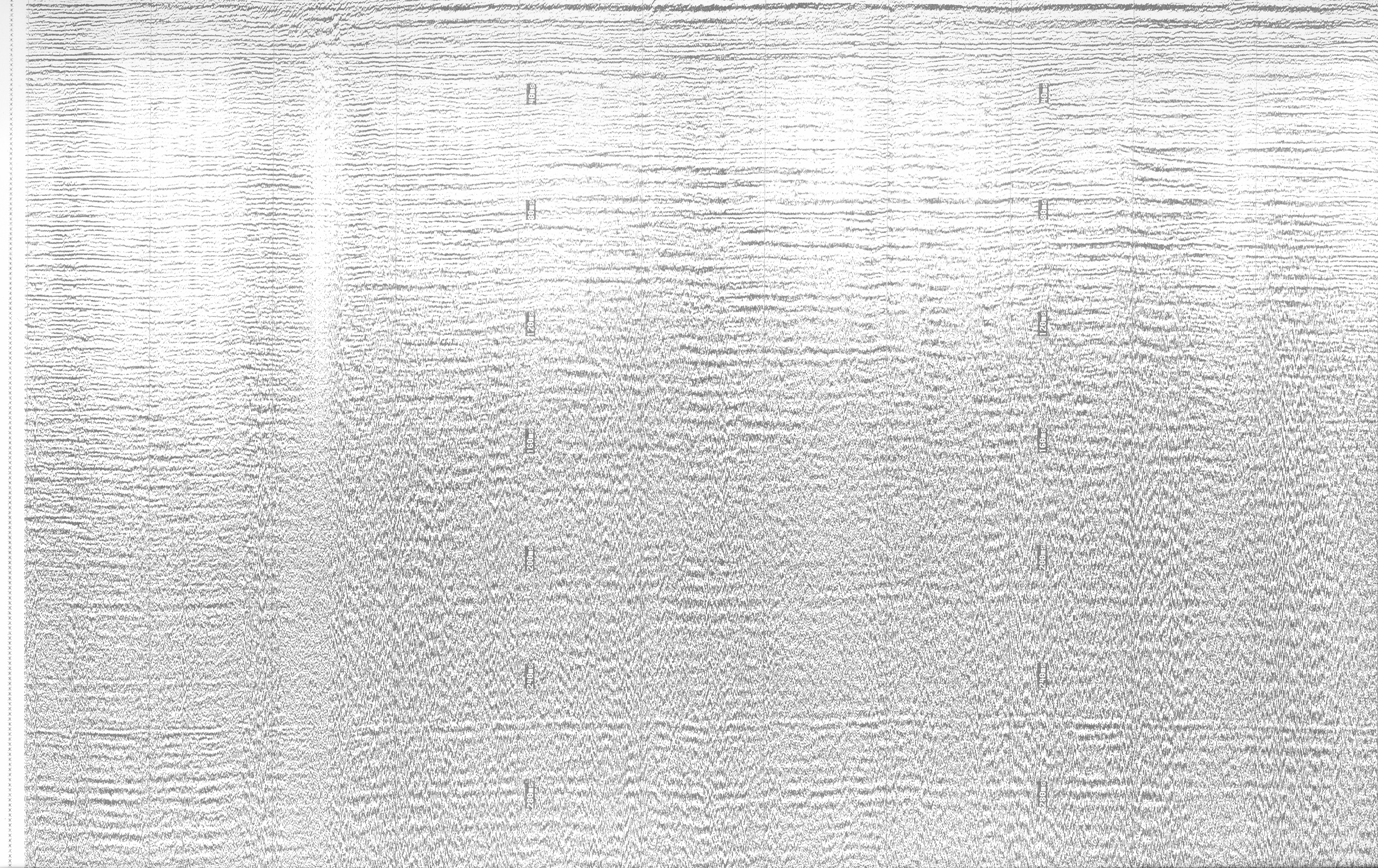
Image of the
Wallops paleovalley(s)
Seismic line AI-05.05a
(jpg)
View is N on the left, S on the
right; vertical tics are 5 m; horizontal tics 200 m
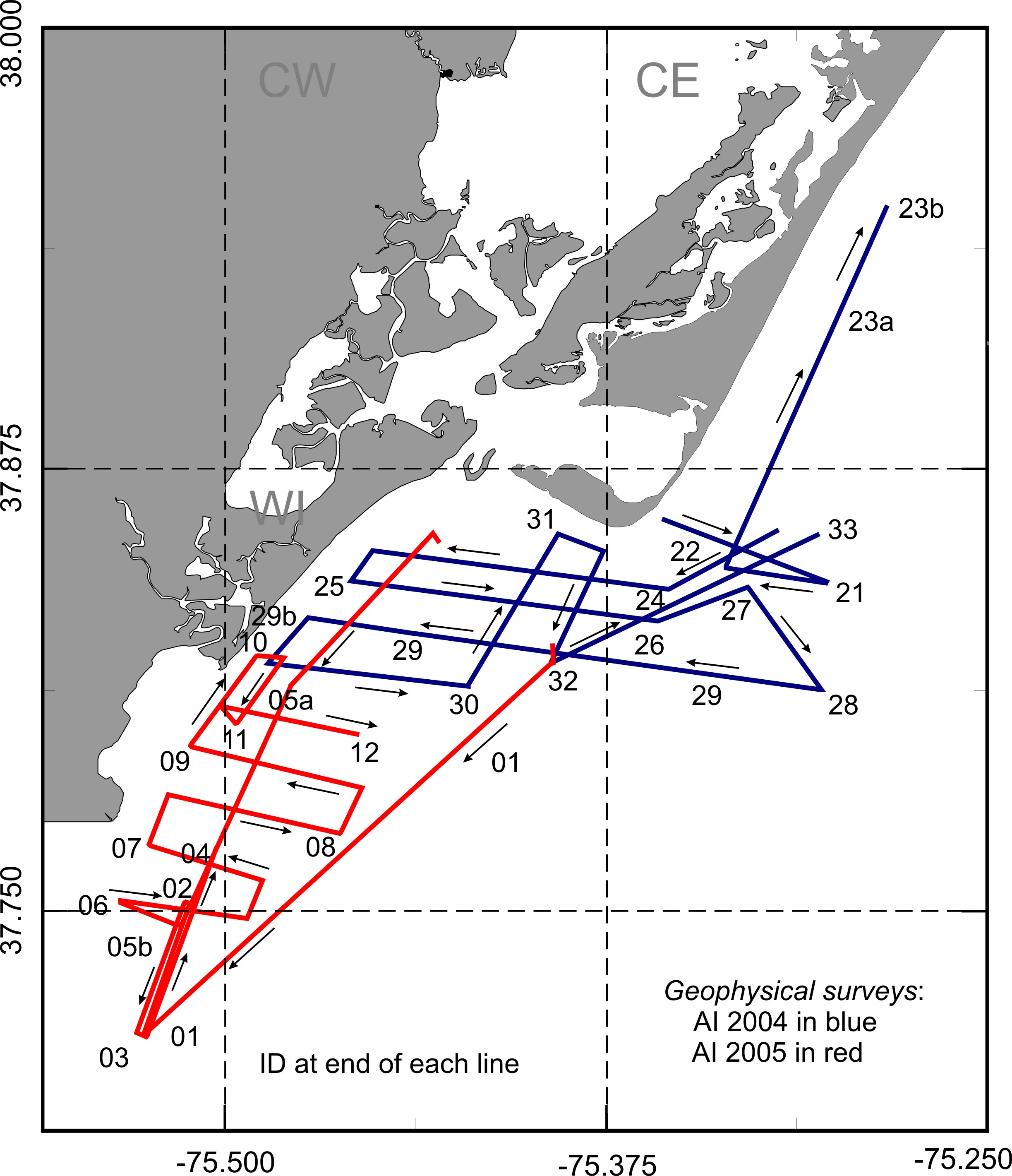
Map
of seismic lines in the Chincoteague Bight