 Index
map. For discussion purposes only - send e-mail if you have questions or comments
Index
map. For discussion purposes only - send e-mail if you have questions or commentsLiberty Township, Seneca County, Ohio
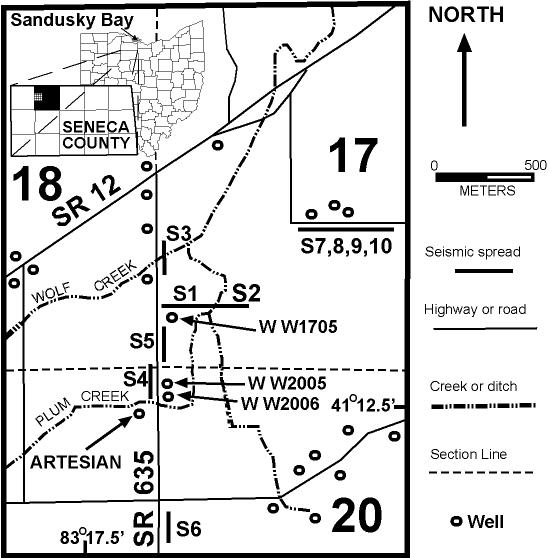
When a water well driller failed to strike bedrock and water at the usual depth for this area, we used geophysical methods to (first) look for bedrock and (later) to map an enormous hole in the Lockport Dolomite. This hole is almost 900 meters in diameter and at least 100 meters deep. This hole has been filled in with lake sediments (to the best we can tell) prior to being covered with 10 meters of till.
Another water well attempt on Sept. 1, 1998 encountered anomalous rock. Instead of over 70 meters of dolomite, the driller struck shale within 20 meters of the surface (we were there to collect samples this time). This well was drilled into elevated rocks on the northwest rim of what we call "Liberty crater". Although reviewers have rejected the first paper we submitted, stating that our evidence is insufficient, they did not suggest another explanation for this hole with uplifted rim.
If this structure were observed on Mars, with uplifted rim and without the sediment fill and till cover, astronomers would identify it as an impact crater. Most of our evidence is geophysical, but we do have critical direct observations (lack of rock to 70 meters in one borehole, uplifted rock layers in another) that fit the impact crater model.
If you think otherwise, feel free to suggest an appropriate wager.
Following the custom of naming geological structures after locations, we choose to name this crater after the township. There is already a Wolfe Creek crater (Australia) and a "Seneca anomaly", so those potential names were already taken.
Index
map. For discussion purposes only - send e-mail if you have questions or comments
Page updated 09/18/01 .
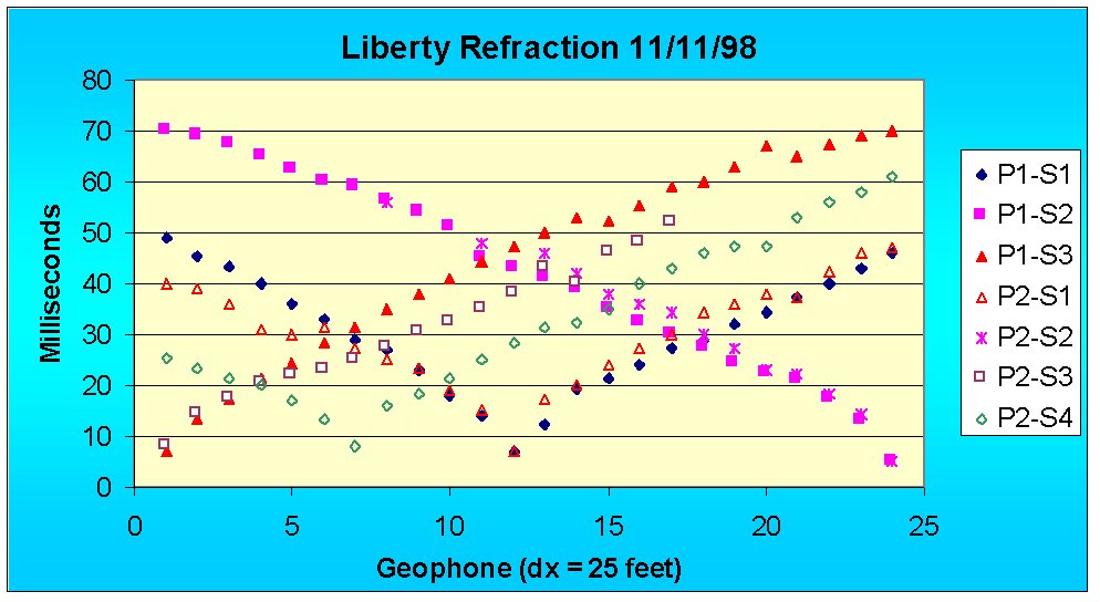 Note that
the north (left) end of Profile 2 is faster than the north end of Profile 1.
"P" is for profile, "S" is for shot. P2S3 is shot 3 of profile
2, Liberty Project, 11/11/98.
Note that
the north (left) end of Profile 2 is faster than the north end of Profile 1.
"P" is for profile, "S" is for shot. P2S3 is shot 3 of profile
2, Liberty Project, 11/11/98.
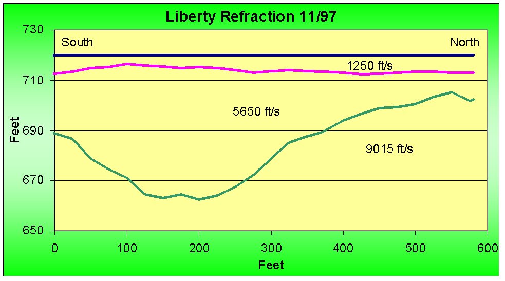 Dr.D's
interpretation of a refraction profile shot 11/11/97. The entire spread lies over
the crater, although a shot offset over 200 feet north of the spread shows evidence that
the shot was placed over shallow carbonate bedrock. I concluded that high apparent
velocities were due to dips in the till (5650 ft/s) contact with basin fill sediment (9015
ft/s) because examination of seismograms revealed NO secondary phases where the change in
apparent velocity appeared on the time-distance graph. Geologically, this means
that the surface of the crater fill (carbonate-cemented silt and clay) was eroded,
probably by glaciation.
Dr.D's
interpretation of a refraction profile shot 11/11/97. The entire spread lies over
the crater, although a shot offset over 200 feet north of the spread shows evidence that
the shot was placed over shallow carbonate bedrock. I concluded that high apparent
velocities were due to dips in the till (5650 ft/s) contact with basin fill sediment (9015
ft/s) because examination of seismograms revealed NO secondary phases where the change in
apparent velocity appeared on the time-distance graph. Geologically, this means
that the surface of the crater fill (carbonate-cemented silt and clay) was eroded,
probably by glaciation.
 Dr.
D's interpretation of 11/11/98 refraction profile 2. Too bad we had so much wind -
some first arrivals were impossible to identify. I split the data into 2 sets: one
north of geophone 8, the other south of geophone 7. The 9160 ft/s is not present to
the north, where the refractor exhibits a P-wave velocity closer to 12,000 ft/s. I
fixed the layer 2 velocity to conform with till velocities elsewhere because there are not
enough first arrivals to sufficiently constrain the value.
Dr.
D's interpretation of 11/11/98 refraction profile 2. Too bad we had so much wind -
some first arrivals were impossible to identify. I split the data into 2 sets: one
north of geophone 8, the other south of geophone 7. The 9160 ft/s is not present to
the north, where the refractor exhibits a P-wave velocity closer to 12,000 ft/s. I
fixed the layer 2 velocity to conform with till velocities elsewhere because there are not
enough first arrivals to sufficiently constrain the value.
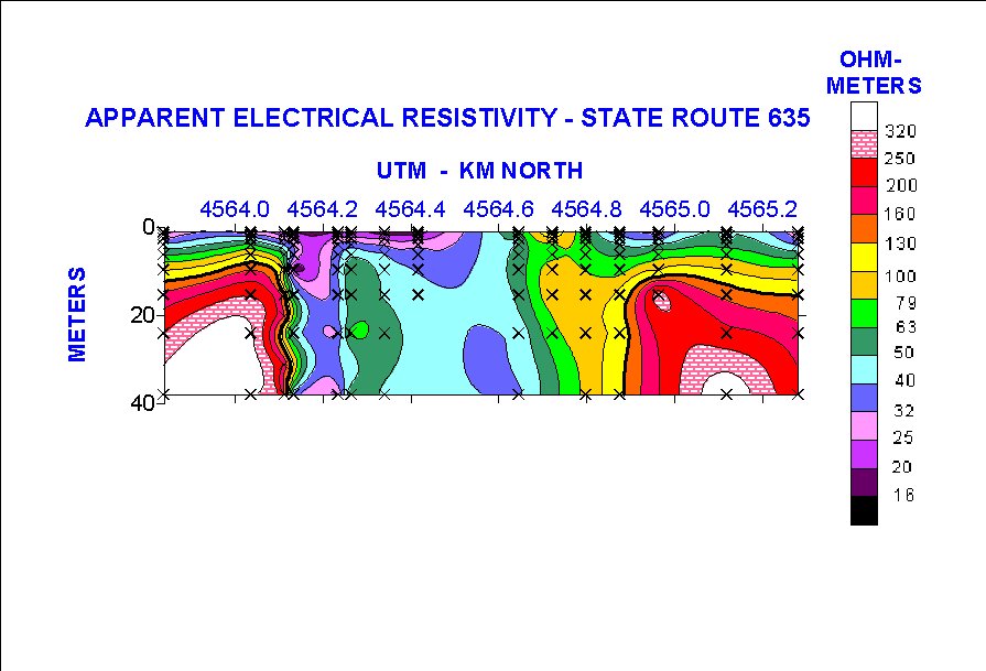 Electrical
resistivity sounding results along State Route 635. Apparent resistivities
(Schlumberger array) are plotted at their effective depths (see Edwards, 1977, Geophysics,
p. 1020). Vertical exaggeration = 10X. Dolomitic bedrock (red,
white) disappears abruptly as we cross the crater lip. Bradley
Trytten (M.S., 1995) made these measurements. Low resistivities near
4564.1 km north are associated with a zone of salt water, origin unknown but
perhaps derived from oil field brines in the Trenton, 400 meters or more below
the surface.
Electrical
resistivity sounding results along State Route 635. Apparent resistivities
(Schlumberger array) are plotted at their effective depths (see Edwards, 1977, Geophysics,
p. 1020). Vertical exaggeration = 10X. Dolomitic bedrock (red,
white) disappears abruptly as we cross the crater lip. Bradley
Trytten (M.S., 1995) made these measurements. Low resistivities near
4564.1 km north are associated with a zone of salt water, origin unknown but
perhaps derived from oil field brines in the Trenton, 400 meters or more below
the surface.
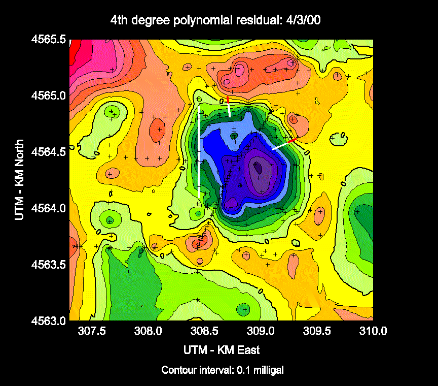 ChromaDepthTM-compatible
residual gravity contour map with 2 refraction lines superimposed. Ask Dr.D. to borrow the glasses
if you haven't purchased a set of your own. Short red/white lines
are locations of seismic refraction profiles that cross the rim. Long
white north-south line is that part of an electrical resistivity profile not
underlain by shallow dolomitic bedrock. Small "+" symbols show
gravity station locations. Data quality varies as these measurements were
made using 4 different gravity meters with at least 4 different gravity meter
operators between 1993 and 2000. Now that we have our own meter and know
where most of the crater is located, watch for updates as we fill in poorly
covered areas and obliterate low quality stations with new, dense measurements
(slide prepared 4/5/00).
ChromaDepthTM-compatible
residual gravity contour map with 2 refraction lines superimposed. Ask Dr.D. to borrow the glasses
if you haven't purchased a set of your own. Short red/white lines
are locations of seismic refraction profiles that cross the rim. Long
white north-south line is that part of an electrical resistivity profile not
underlain by shallow dolomitic bedrock. Small "+" symbols show
gravity station locations. Data quality varies as these measurements were
made using 4 different gravity meters with at least 4 different gravity meter
operators between 1993 and 2000. Now that we have our own meter and know
where most of the crater is located, watch for updates as we fill in poorly
covered areas and obliterate low quality stations with new, dense measurements
(slide prepared 4/5/00).
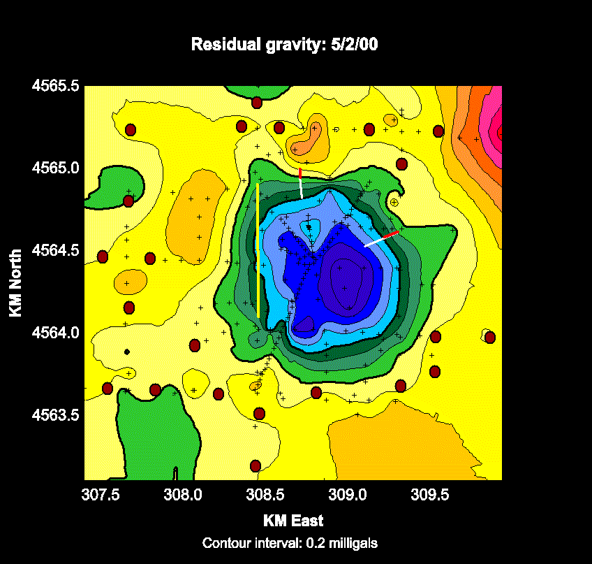 Fit
it again, Sam. 27 more stations occupied and some old station elevations
cleaned up. 22 stations used to calculate the 4th degree polynomial fit,
stations well away from the crater, are shown by chocolate-colored circles. Crops will be planted soon so
expeditions (if any) during the next few months will be restricted to fence
lines and other ground not under cultivation. As coverage improves, the
anomaly becomes more circular.
Fit
it again, Sam. 27 more stations occupied and some old station elevations
cleaned up. 22 stations used to calculate the 4th degree polynomial fit,
stations well away from the crater, are shown by chocolate-colored circles. Crops will be planted soon so
expeditions (if any) during the next few months will be restricted to fence
lines and other ground not under cultivation. As coverage improves, the
anomaly becomes more circular.
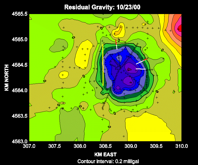 Updated
10/23/00. 28 new gravity stations in the southeast quadrant of the
crater. I wonder where to go next? The northeast quadrant is planted
in winter wheat. There are some "warts" to deal with in the
southwest quadrant.
Updated
10/23/00. 28 new gravity stations in the southeast quadrant of the
crater. I wonder where to go next? The northeast quadrant is planted
in winter wheat. There are some "warts" to deal with in the
southwest quadrant.
 Updated 10/26/00. Only 12 new stations (I got a late start) but they
really cleaned up the southeast corner! I'll post more next week - unless
it rains.
Updated 10/26/00. Only 12 new stations (I got a late start) but they
really cleaned up the southeast corner! I'll post more next week - unless
it rains.
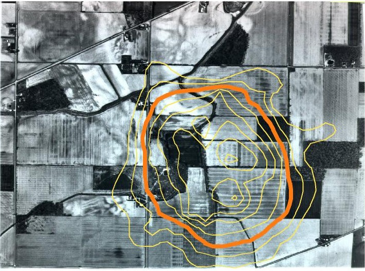 Residual
gravity superimposed on aerial photograph. Heavy orange contour represents best estimate for top of crater rim, based on seismic refraction
an
Residual
gravity superimposed on aerial photograph. Heavy orange contour represents best estimate for top of crater rim, based on seismic refraction
an
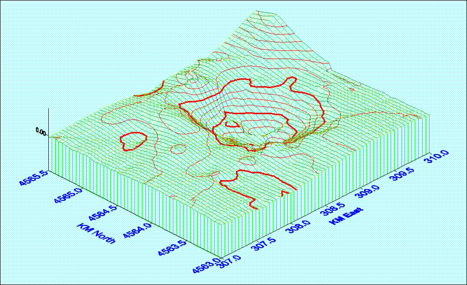 Perspective plot, view from the southwest. I wonder if that local gravity
high on the floor of the crater is a large landslide. There appears to be
a bit of the rim missing (note arrow) from the northwest side based on gravity,
refraction and EM34 surveys. Surface
plot updated 10/23/00.
Perspective plot, view from the southwest. I wonder if that local gravity
high on the floor of the crater is a large landslide. There appears to be
a bit of the rim missing (note arrow) from the northwest side based on gravity,
refraction and EM34 surveys. Surface
plot updated 10/23/00.