The Broad Field of Geology
Environmental Geology: Geologists investigating our environment
Ecology and Geology: The interplay between the animate and the physical
Geology of Northwest Ohio
Limestone, Siluro-Devonian (~420 to 400 million years ago)
Glacial Drift (Till), Wisconsinan (~24,000 to 14,000 years ago)
Lacustrine (lake) Sediments, Holocene (~10,000 to 8,000 years ago)
Oak Openings Hydrogeology (~200 years ago to present)
Case Studies
Stranahan Arboretum: an example of Oak Openings Ecology and Hydrogeology
Hydrogeological Investigations: Why study groundwater and contamination?
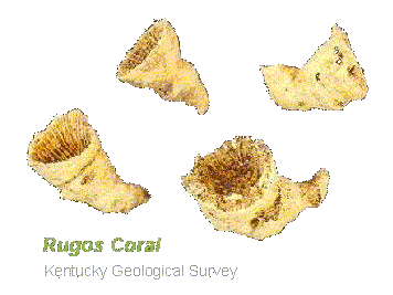
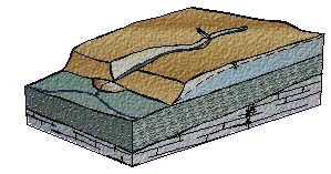
Imagine that you are near the shore of a shallow tropical sea approximately 400 million years ago (mya). You might expect to see coral reefs inhabited by shelled marine animals (e.g., Brachiopods
) and other marine invertebrates (e.g., Trilobites). Because many of these creatures secrete calcareous shells or body structures, their decay and subsequent abrasion by currents and turbulence produces a calcareous mud. Once this mud is compacted and cemented together (i.e., lithified) the result is a fossiliferous limestone
that constitutes the bedrock beneath much of northwest Ohio. The limestone was compacted by the deposition of several hundred feet of overlying sediments that recorded the history of the uplift and erosion of the Appalachian Mountains: shale, indicating mud washing into a formerly clear sea and sandstone, indicating near shore thoroughly washed beach sediments.
This history is preserved in the geology of Michigan and Northeast Ohio but has been lost to erosion here in Toledo due to the uplift of the Findley Arch, a hundred mile wide up warp in the bedrock of northern Ohio. This erosion carved an ancient drainage pattern in the bedrock including the ancestral Maumee River and the Teays River which once flowed to the northwest in the opposite
direction of the current drainage patterns. More detail on the geological history of Ohio can be found at the Ohio Department of Natural Resources Division of Geological Survey and their web site
http://www.ohiodnr.com/geosurvey/geo_fact/geo_f23.htm
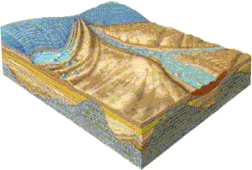
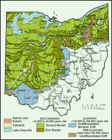
Fast forward about 400 million years to the next major geological event recorded in northern Ohio and Michigan, the Wisconsinan Glaciation. During the last ice age a continental glacier advanced to southern Ohio, plowing anything in its path southward and plastering over the ancestral drainage system. The material plowed and plastered is mostly clay with some sand and silt all mixed together into a dense, poorly sorted, impermeable material know as glacial drift. The result was a largely flat lying, poorly drained region that we in northwest Ohio are so familiar with and that eventually developed into the largest wetland in the Lake Erie Basin, the Great Black Swamp. This vast wetland, which was approximately half the size of the Everglades, was progressively drained as European settlers cultivated the fertile organic rich soils for agricultural production.
 entirely different from the shallow tropical sea
of the early Devonian Period 400 mya. As
the ice age waned, the receding continental glacier covered the present-day
Niagara River, Lake Ontario and the St. Lawrence Seaway and dammed the outlet to
the Lake Erie basin. The melt water
that flowed from beneath the receding glacier backed up to form large glacial
lakes in the vicinity of the present-day southern Great Lakes.
As with the present day Great Lakes these lakes deposited silt and clay (lacustrine
sediments) in the deeper offshore regions and sandy beaches along their shores.
As the glaciers receded further the glacial lakes also receded leaving behind a
series of beach ridges that document the history of these ancestral Great Lakes.
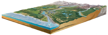
The sand of the Oak Openings Region of northwest Ohio is an excellent
example of these beach sediments showing a distinct beach ridge morphology and
many remnant dunes. The higher
dunes of the region led to drier soils upon which oak trees thrived and lower
wet areas where the water table is shallow which supported a wet prairie
ecosystem, hence the name Oak Openings.
entirely different from the shallow tropical sea
of the early Devonian Period 400 mya. As
the ice age waned, the receding continental glacier covered the present-day
Niagara River, Lake Ontario and the St. Lawrence Seaway and dammed the outlet to
the Lake Erie basin. The melt water
that flowed from beneath the receding glacier backed up to form large glacial
lakes in the vicinity of the present-day southern Great Lakes.
As with the present day Great Lakes these lakes deposited silt and clay (lacustrine
sediments) in the deeper offshore regions and sandy beaches along their shores.
As the glaciers receded further the glacial lakes also receded leaving behind a
series of beach ridges that document the history of these ancestral Great Lakes.
The sand of the Oak Openings Region of northwest Ohio is an excellent
example of these beach sediments showing a distinct beach ridge morphology and
many remnant dunes. The higher
dunes of the region led to drier soils upon which oak trees thrived and lower
wet areas where the water table is shallow which supported a wet prairie
ecosystem, hence the name Oak Openings.