Miscellaneous notes
Quarries are numbered and ordered from north to south. In the case of limestone and sandstone, the quarries are grouped according to region and geologic formation. The formation descriptions apply only to areas bordering the Nile River. All quarries are plotted on the accompanying maps. Coordinates for the approximate quarry centers are based on the WGS 84 datum and correspond with locations visible in Google Earth.
Quarry age and size are given in parentheses after the quarry location. Abbreviations for age are: Paleo = Palaeolithic, Neo = Neolithic, Pd = Predynastic, ED = Early Dynastic, OK = Old Kingdom, 1IP = First Intermediate Period, MK = Middle Kingdom, 2IP = Second Intermediate Period, NK = New Kingdom, 3IP = Third Intermediate Period, LP = Late Period, Pt = Ptolemaic, R = Roman, B = Byzantine or Late Roman, and Is = Islamic. Other abbreviations include: OK:4 = Fourth Dynasty of the Old Kingdom, OK/MK = Old Kingdom and/or Middle Kingdom, and NK-R = New Kingdom through Roman Period. Size corresponds to the maximum dimension of an area of quarry workings or the cumulative maximum dimensions for multiple areas of workings within a single quarry. Three size classes are recognized: small (<100 m), medium (100-1000 m), and large (>1000 m).
The standard Udden-Wentworth grain-size scale is used for sandstones: gravel (in conglomeritic sandstone) > 2 mm, very coarse sand 1-2 mm, coarse sand 0.5-1 mm, medium sand 0.25-0.5 mm, fine sand 0.125-0.25 mm, very fine sand 0.0625-0.125 mm, and silt < 0.0625 mm. The predominant grain size for limestones is characterized as: coarse > 1 cm, medium 2 mm-1 cm or fine <2 mm, where the grains (all larger than 0.03 mm) are fossil bioclasts, non-skeletal carbonate grains (e.g., ooliths and peloids) and non-carbonate grains (e.g., quartz silt and sand). Carbonate mud is composed of material finer than 0.03 mm. The popular Dunham (1962) textural classification is applied to the limestones: mudstone (nearly all carbonate mud with rare grains), wackestone (mostly carbonate mud with common grains), packstone (mostly grains with carbonate mud filling the interstices), and grainstone (mostly grains with calcite cement filling the interstices).
The ancient names for limestone were inr HD nfr n ain (iner hedj nefer n ain) and inr HD nfr n r-Aw (iner hedj nefer n raw), both translating as “fine (nfr) white (inr HD) stone of Tura-Masara (ain or r-Aw with these terms referring, respectively, to the cave-like quarry openings and the nearby geothermal springs at Helwan)”. In the Old Kingdom these names referred specifically to the Tura-Masara limestones but later they were applied to all such rocks irrespective of source. In these names, the nfr or HD or even both were sometimes omitted.
Mediterranean Coast
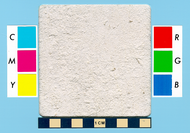
Alexandria Formation (Pleistocene): fine-grained, packstone to mainly grainstone with mostly non-skeletal carbonate grains (especially ooliths and coated grains), making it a “oolitic limestone” or a “carbonate sandstone” or “calcarenite” due to abundant sand-sized carbonate grains. Non-clayey, non-dolomitic, and non-siliceous, but occasionally has detrital quartz silt and sand.
1. in eastern Mallahet Mariut marsh on north side southwest of Alexandria—largely destroyed [31o 6.89’ N, 29o 47.66’ E] (Pt & mainly R-B; medium)
2. in western Mallahet Mariut marsh on both north and south sides near and
between Abusir, Burg el-Arab, and el-Hawariya villages [30o
56.98’ N, 29o 34.42’ E] (R-B; large)
Nile Valley
Observatory Formation of the Mokattam Group (Middle Eocene, Lutetian stage): medium- to coarse-grained packstone to mainly fine-grained mudstone and wackestone with foraminifera (especially nummulitids, making it at times a “nummulitic limestone,” but also commonly operculinids, globigerinids, globoratalids and others) and lesser amounts of other invertebrates, mostly echinoids. Occasionally dolomitic, gypsiferous, and clayey (marly) with common detrital quartz silt and sand. Slightly siliceous with nearly ubiquitous microscopic secondary quartz.
3. at Zawyet Nasr on Gebel Mokattam southeast of Citadel, East Bank—partially destroyed [30o 1.50’ N, 31o 16.37’ E] (OK-LP?; medium)
4. at Giza pyramids, West Bank [29o 58.55’ N, 31o 7.94’ E] (OK:4; large)
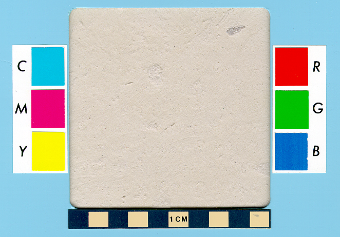
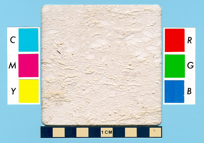
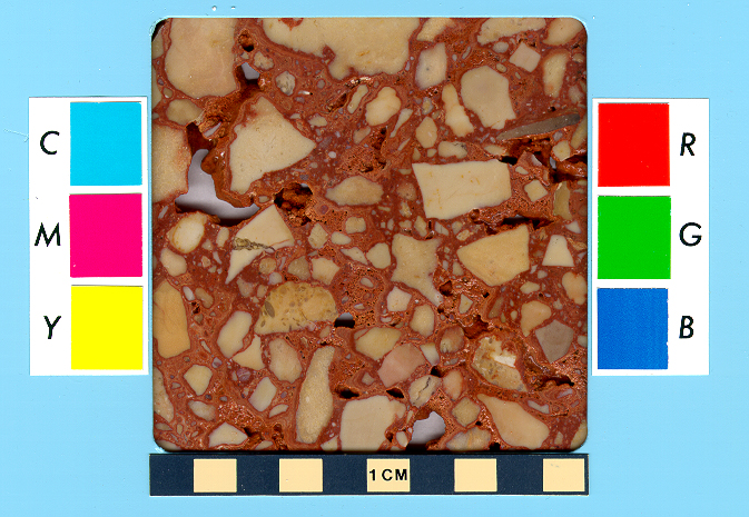
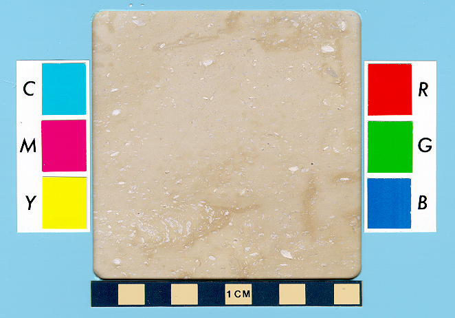
5. at Gebel Tura east of Tura village, East Bank—partially destroyed [29o 56.05’ N, 31o 17.89’ E] (ED:3, OK:4-R; large) PHOTO: sample 1
6. at Gebel Hof east of el-Masara village, East Bank—partially destroyed [29o 54.91’ N, 31o 19.68’ E] (ED:3, OK:4-R; large) PHOTO: sample 1
7. near Abusir pyramids, West Bank [29o 52.98’ N, 31o 12.25’ E] (OK:5; medium)
8. at Saqqara pyramids, West Bank [29o 52.29’ N, 31o 12.87’ E] (ED:3; small)
Wadi Rayan Formation of the Mokattam Group (Middle Eocene, Lutetian stage): coarse-grained packstone with mainly oysters (making it a “coquinal limestone”) and lesser amounts of other invertebrates (mostly echinoids). Non-dolomitic, non-clayey and non-siliceous, but with common detrital quartz sand (at times making it almost a calcareous sandstone).
9. at Dahshur pyramids, West Bank [29o 48.50’ N, 31o 12.38’ E] (OK:4, MK:12; small)
10. at Sadd el-Kafara in Wadi Garawi east of Helwan city, East Bank [29o 47.74’ N, 31o 25.91’ E] (OK:4-5; medium)
11. north and south of el-Lisht pyramids, West Bank [29o 33.61’ N, 31o 13.27’ E] (MK:12; medium)
12. at el-Lahun pyramid, West Bank [29o 14.17’ N, 30o 58.25’ E] (MK:12; medium)
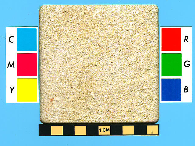
Samalut Formation of the Mokattam Group (Middle Eocene, Lutetian stage): medium- to mainly coarse-grained packstone and grainstone with mainly nummulitid foraminifera (making it a “nummulitic limestone”), and lesser amounts of other invertebrates, mostly echinoids and alveolinid foraminifera. Essentially non-silty/sandy, non-clayey, and non-dolomitic, but slightly siliceous with nearly ubiquitous microscopic secondary quartz.
13. east of el-Sawayta village, East Bank [28o 22.36’ N, 30o 48.83’ E] (NK-LP?; large)
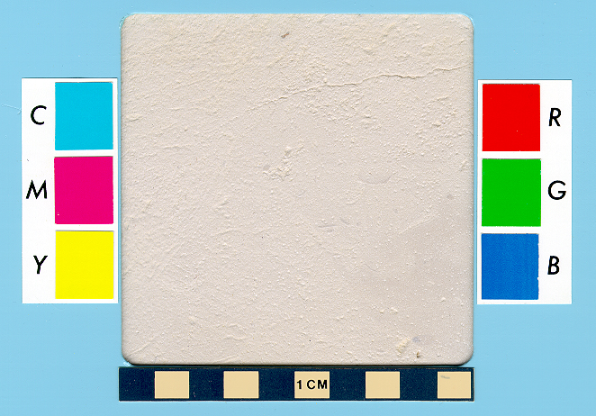
14. at el-Babein northeast of Beni Khalid village, East Bank [28o 18.28’ N, 30o 45.06’ E] (OK/MK?, NK:19-20; medium) PHOTO: sample 1
15. within and east of Deir Gebel el-Teir village, East Bank [28o 16.90’ N, 30o 45.46’ E] (OK/MK?; large)
16. east and south of Tihna el-Gebel village near Akoris ruins, East Bank [28o 10.97’ N, 30o 46.54’ E] (NK-R; medium)
17. east of el-Hawarta village, East Bank [28o 9.97’ N, 30o 46.72’ E] (R?; large)
18. north and southeast of Nazlet Hussein Ali village, East Bank [28o 7.69’ N, 30o 46.93’ E] (R; large)
19. east and north of Nazlet Sultan Pasha village and west of New el-Minya city, East Bank [28o 4.41’ N, 30o 48.74’ E] (NK:18 & Pt-R; large)
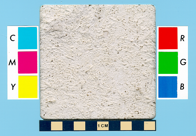
20. east and southeast Zawyet el-Amwat village, East Bank [28o 3.16’ N, 30o 50.01’ E] (NK & Pt-R?; medium) PHOTO: sample 1
21. in Wadi Sheikh Yasin east of Zawyet el-Amwat village, East Bank—partially destroyed [28o 3.05’ N, 30o 50.81’ E] (NK-R?; medium)
22. near Darb Tila Nufal southeast of Zawyet el-Amwat village, East Bank [28o 2.57’ N, 30o 51.44’ E] (age?; large)
31. west of Tuna el-Gebel tombs, West Bank [27o 44.22’ N, 30o 41.71’ E] (Pt-R; small)
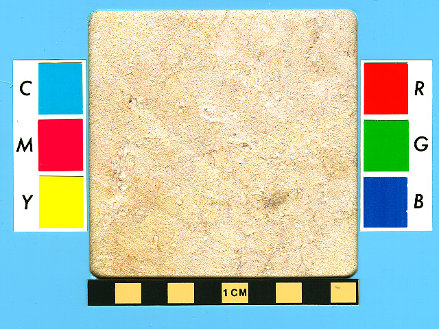
Minia Formation (late Early Eocene to early Middle Eocene, Ypresian to Lutetian stages): fine- to medium-grained, wackestone and packstone to less often grainstone with mainly echinoids and foraminifera (especially alveolinids and nummulitids), and lesser amounts of other invertebrates and non-skeletal peloids. Essentially non-silty/sandy, non-clayey and non-dolomitic, but slightly to moderately siliceous with microscopic secondary quartz.
23. northeast of Nazlet Abu Ginah village, East Bank [27o 58.12’ N, 30o 52.44’ E] (R?; small)—possibly lower part of Samalut Fm.
24. at Beni Hassan tombs, East Bank [27o 55.52’ N, 30o 52.47’ E] (age?; small)—possibly lower part of Samalut Fm.
25. east of Beni Hassan el-Shuruq village, East Bank [27o 54.36’ N, 30o 52.25’ E] (OK/MK-R; large); possibly lower part of Samalut Fm. PHOTO: sample 1 ; sample 2
26. northeast, east and southeast of Nag Arab Misallam Abu Mubarik village, East Bank [27o 52.81’ N, 30o 51.85’ E] (age?; medium); possibly lower part of Samalut Fm.
27. southeast of el-Sheikh Timay village, East Bank—partially destroyed [27o 51.55’ N, 30o 51.00’ E] (OK/MK-Pt?; small); possibly lower part of Samalut Fm.
28. north and northeast of el-Sheikh Ibada village and Antinoopolis ruins, East Bank [27o 49.68’ N, 30o 52.28’ E] (MK? & R-B; large); possibly lower part of Samalut Fm.
29. northeast, east, and southeast of Deir Abu Hennis village, East Bank [27o 46.76’ N, 30o 55.28’ E] (NK:18; large)
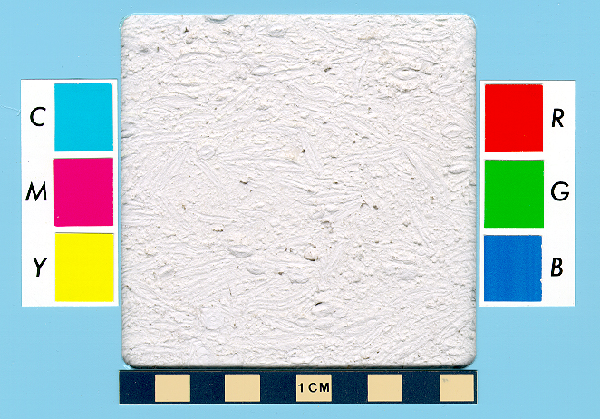
30. northeast and east of Deir el-Bersha village and in Wadi el-Nakhla, East Bank [27o 45.34’ N, 30o 55.23’ E] (MK?, NK:18, L:30; large) PHOTO: sample 1
32. south of el-Bersha village, East Bank [27o 43.15’ N, 30o 53.67’ E] (NK:18; small)
33. on Gebel Sheikh Said north and south of entrance to Wadi el-Zebeida, East Bank [27o 42.05’ N, 30o 53.38’ E] (NK:18; medium)
34. in Wadi el-Zebeida, including Abd el-Azzis travertine quarry, East Bank [27o 41.47’ N, 30o 54.24’ E] (MK?; medium)
35. north and east of el-Amarna ruins and Beni Umran village, East Bank [27o 40.36’ N, 30o 55.17’ E] (NK:18; large)
36. at South Tombs south of el-Amarna ruins, East Bank [27o 36.50’ N, 30o 54.92’ E] (NK:18; small)
37. near Hatnub travertine quarry southeast of el-Amarna ruins, Eastern Desert [27o 33.40’ N, 31o 0.93’ E] (NK:18; small)
38. on Gebel Abu Foda opposite the West Bank’s el-Mandara Bahri village, East Bank [27o 29.78’ N, 30o 52.44’ E] (age?; small)
39. east of Deir el-Quseir village on Gebel Abu Foda, East Bank [27o 29.78’ N, 30o 52.44’ E] (age?; medium)
40. west of Meir village, West Bank [27o 25.99’ N, 30o 42.34’ E] (OK/MK?; small)
41. southeast of Quseir el-Amarna village in and near Wadi Abu Helwa and Wadi Magberi on Gebel Abu Foda, East Bank [27o 25.48’ N, 30o 52.71’ E] (OK/MK-NK; large)
42. at Deir el-Amir Tadros monastery on Gebel Abu Foda, East Bank—partially destroyed [27o 22.81’ N, 30o 57.46’ E] (OK/MK? & NK:19; small?)
43. at, and south of, Deir Abu Mina monastery on Gebel el-Harrana, East Bank—partially destroyed [27o 21.38’ N, 31o 0.91’ E] (LP-R?; medium) PHOTO: sample 1
44. at el-Ketf promontory east and southeast of el-Maabda village on Gebel el-Harrana, East Bank—partially destroyed [27o 19.62’ N, 31o 2.91’ E] (NK:19 & LP; medium)
45. north of Deir el-Gabrawi village on Gebel el-Tawila, East Bank—partially destroyed [27o 20.34’ N, 31o 6.19’ E] (NK:19; medium)
46. north of Arab el-Atiat el-Bahriya village on Gebel el-Harrana, East Bank [27o 20.02’ N, 31o 3.88’ E] (Pt-R; medium)
47. at Talet el-Hagar promontory north of entrance to Wadi el-Assiut, East Bank [27o 17.33’ N, 31o 18.01’ E] (age?; medium); possibly upper part of Serai Fm.
Drunka Formation of the Thebes Group (Early Eocene, Ypresian stage): fine-grained mudstone and grainstone to mainly wackestone and packstone with primarily foraminifera (mostly nummulitids, alveolinids and operculinids), echinoids and nonskeletal peloids, and lesser amounts of other invertebrates, mostly bivalves, gastropods and calcareous algae. Essentially non-silty/sandy and non-dolomitic, but occasionally clayey (marly) and slightly to moderately siliceous with microscopic secondary quartz.
48. on Gebel Drunka west of Assiut city, West Bank—partially destroyed [27o 9.73’ N, 31o 10.21’ E] (MK-NK; medium)
49. northeast of el-Matmar village and south of entrance to Wadi Emu, East Bank—largely destroyed [27o 7.18’ N, 31o 21.40’ E] (NK; small)
50. north, west and south of Deir Drunka village and at Deir el-Adra Maryam monastery, West Bank [27o 6.46’ N, 31o 10.06’ E] (OK/MK?; large)
51. north and east of el-Khawalid village, East Bank [27o 5.55’ N, 31o 23.31’ E] (age?; medium )
52. northwest and west of Deir Rifa village, West Bank [27o 4.62’ N, 31o 11.00’ E] (NK & later?; medium)
53. east of Nazlet el-Mustagidda village, East Bank [27o 4.47’ N, 31o 23.73’ E] (age?; small)
54. between Nazlet el-Mustagidda and el-Ruwegat villages, East Bank [27o 3.80’ N, 31o 24.30’ E] (age?; medium)
55. southwest of el-Zawya village, West Bank [27o 2.58’ N, 31o 13.61’ E] (age?; medium)
56. west of el-Balayza village, West Bank [27o 0.69’ N, 31o 14.56’ E] (OK/MK?; medium)
57. northeast of el-Iqal Bahri village, East Bank [26o 59.55’ N, 31o 27.55’ E] (age?; medium)
58. west of el-Zaraby village, West Bank [26o 58.48’ N, 31o 15.12’ E] (OK/MK-NK?; medium)
59. south of el-Sheikh Isa village, East Bank [26o 57.61’ N, 31o 27.68’ E] (age?; small)
60. east of el-Iqal el-Qibli village, East Bank [26o 56.57’ N, 31o 28.82’ E] (R?; medium)
61. at Deir el-Ganadla monastery, West Bank—partially destroyed [26o 55.65’ N, 31o 17.00’ E] (OK/MK?; medium)
62. north, east, and south of el-Hammamiya village, East Bank [26o 55.71’ N, 31o 29.45’ E] (OK/MK?-NK:18; medium)
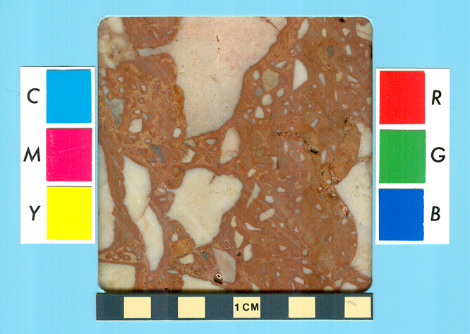
63. north and northeast of Antaeopolis ruins and former Qaw el-Kebir village,
East Bank [26o
55.63’ N, 31o 30.31’ E] (OK/MK-NK?, Pt-R; medium)
PHOTO: limestone - sample 1 ; sample 2 ; red-and-white limestone breccia from nearby
modern quarry - sample 3
64. northwest of el-Mashaya village, West Bank [26o 54.93’ N, 31o 17.36’ E] (age?; medium)
65. northwest and west of el-Ghanayim village, West Bank [26o 52.63’ N, 31o 18.96’ E] (NK/LP? & R; medium)
66. northwest and west of el-Qutna village, West Bank [26o 51.61’ N, 31o 19.75’ E] (age?; large?)
67. west of el-Qarya Bil Diweir village, West Bank [26o 50.53’ N, 31o 20.10’ E] (age?; medium)
68. southeast of el-Nawawra village, East Bank [26o 50.15’ N, 31o 32.12’ E] (OK/MK-NK?; medium)
69. north of el-Khazindariya village on Gebel el-Haridi, East Bank [26o 47.95’ N, 31o 32.29’ E] (NK:20; small)
70. west and south of Nazlet Khatir village, West Bank [26o 46.74’ N, 31o 22.16’ E] (age?; small)
71. north, east and southeast of Nazlet el-Haridi village on Gebel el-Haridi, East Bank [26o 45.14’ N, 31o 33.51’ E] (Pt; medium) PHOTO: sample 1
72. northeast and north of el-Galawiya village on Gebel el-Haridi, East Bank [26o 45.76’ N, 31o 36.47’ E] (OK/MK? in part; medium); possibly upper part of Serai Fm.
73. at Istabl Antar southeast of el-Haradna village, East Bank [26o 42.76’ N, 31o 40.52’ E] (age?; small); possibly upper part of Serai Fm.
74. northwest of el-Ghirizat village, West Bank [26o 37.97’ N, 31o 28.44’ E] (OK/MK-NK?; medium)
75. on Qurnet Salamuni promontory south of Qurnet Salamuni village and northwest of el-Salamuni village, East Bank [26o 37.00’ N, 31o 45.76’ E] (NK:18 & Pt; medium); possibly upper part of Serai Fm.
76. on north side of entrance to Wadi Abu Gilbana, East Bank [26o
35.64’ N, 31o 48.90’ E] (NK:18;
small)
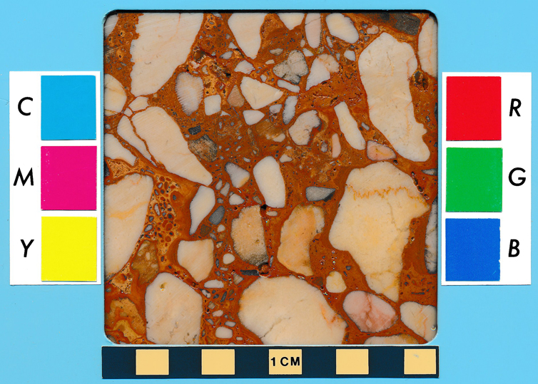
Modern but possibly also ancient (MK? at el-Issawia Sharq) quarries
for red-and-white limestone breccia are nearby on the north side of Wadi Abu
Gilbana [26o
37.07’ N, 31o 50.31’ E; PHOTO: sample 1]
and at el-Issawia
Sharq south of Wadi Abu Gilbana [26o
35.23’ N, 31o 50.71’ E; PHOTO: sample 2]
77. east of Deir el-Abyad el-Bahari (the 'White Monastery'), West Bank [26o 31.85’ N, 31o 38.21’ E] (NK/LP; medium)
78. northwest of Nag Hamad village, West Bank [26o 31.12’ N, 31o 39.03’ E] (age?; medium)
79. southwest of Athribis ruins, West Bank [26o 30.49’ N, 31o 39.87’ E] (Pt-R; medium)
80. southeast of Nag el-Ahaiwah village, East Bank [26o 26.07’ N, 31o 50.27’ E] (3IP; small)
82. west of el-Salmuni village and north of Abydos ruins, West Bank—partially destroyed [26o 11.90’ N, 31o 51.92’ E] (NK? & R; large)
Serai Formation of the Thebes Group (Early Eocene, Ypresian stage): fine-grained wackestone and, less often, packstone with mainly foraminifera (mostly globigerinids, globoratalids, nummulitids and operculinids) and lesser amounts of other invertebrates, mostly bivalves and echinoids. Commonly clayey (marly) and dolomitic with detrital quartz silt and sand, and moderately to highly siliceous with microscopic secondary quartz.
81. on Gebel Tukh, East Bank [26o 24.82’ N, 31o 50.87’ E] (MK &LP-R; large)
83. south of Nag el-Ghabat village and southeast of Abydos ruins, West Bank [26o 9.43’ N, 31o 56.46’ E] (LP:30; medium)
84. at Gebel el-Gir west of el-Tiweirat village, West Bank [26o 6.23’ N, 32o 41.66’ E] (R ?)
85. west of Nag el-Buza village, East Bank [26o 5.62’ N, 32o 18.09’ E] (age?; small); possibly lower part of Drunka Fm.
86. northwest of el-Tarif village and south of New Qurna village, West Bank [25o 44.85’ N, 32o 37.36’ E] (NK:18, LP:26 & R; medium)
89. southeast of el-Ghrera village at north end of el-Gebelein hills, West Bank—completely destroyed [25o 29.88’ N, 32o 28.89’ E] (age?; small) PHOTO: sample 1
Tarawan Formation (Late Paleocene, Thanetian stage): fine-grained mudstone and wackestone with mainly globigerinid foraminifera, and lesser amounts of other invertebrates, mostly other foraminifera. Non-siliceous and non-silty/sandy, but commonly clayey (marly) and dolomitic.
88. northeast of el-Dibabiya village, East Bank [25o 30.08’ N, 32o 31.16’ E] (NK:19, 3IP:21, R; medium) PHOTO: sample 1
91. west of Fatiri village, East Bank [24o 35.43’ N, 32o 54.66’ E] (NK; small)
Durri Limestone (Pliocene): fine-grained mudstone with occasional lacustrine molluscs. Commonly clayey (marly).
87. west of Armant village, West Bank [location uncertain but near 25o 38.5’ N, 32o 21.5’ E] (age?; small)
Quseir Formation (Upper Cretaceous, Early to Late Campanian stage): very fine- to mainly fine- to medium-grained sandstone with, toward the top, interbedded coarse-grained oyster grainstone (cocquina limestone).
90. at el-Kula pyramid, West Bank [25o
8.00’ N, 32o 44.02’ E] (ED:3; small)
Western Desert
Gebel Qatrani Formation (Oligocene): interbedded sandstone and sandy shale with a few lenses of gravelly sandstone and limestone.
92. at Widan el-Faras, northeastern Faiyum Desert [29o 38.84’ N, 30o 37.67’ E] (OK; small)
Moghra Formation (Early Miocene, Aquitanian to Burdigalian stages): medium- to mostly fine-grained packstone with mainly echinoids and pelecypods (especially oysters). Non-clayey, non-silty/sandy, non-dolomitic, and non-siliceous.
93. in Siwa Oasis at Gebels Takrur, Mawta, and Aghurmi, and at Bilat el-Rum
[29o
11.80’ N, 25o 30.00’ E] (Pt-R; medium)
EASTERN DESERT (Wadi Araba area)
Mokattam Group (see above)
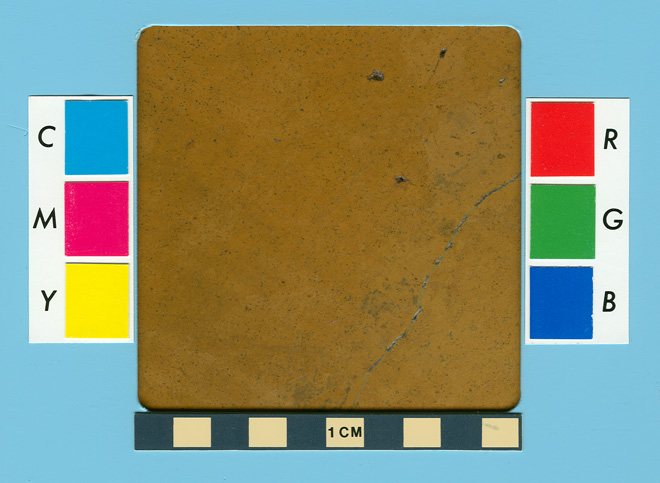
94. in Wadi Umm Zanatir near St. Antony Monastery [28o 56.25' N, 32o 23.86' E] (B & Is?; medium) -- orange calcareous dolostone (mudstone) PHOTO: sample 1
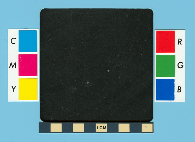
95. in Wadi Abu Mu'aymil near St. Antony Monastery [28o 53.94' N, 32o 19.56' E] (B & Is?; small?) -- light to dark gray and black limestones (mudstone) PHOTOS: sample 1, sample 2, and sample 3
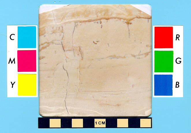
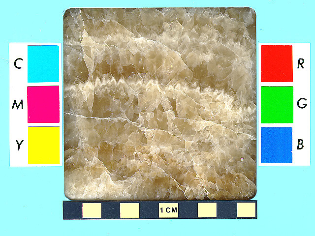
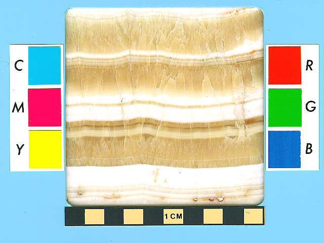
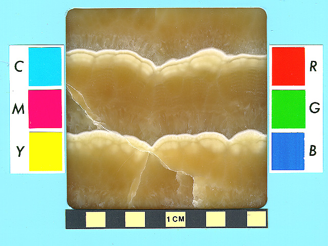
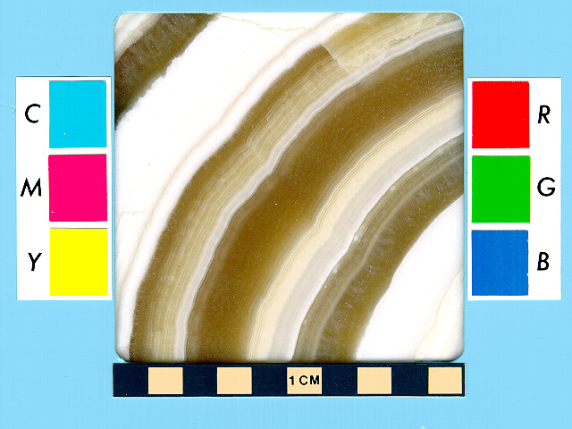
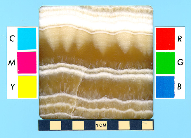
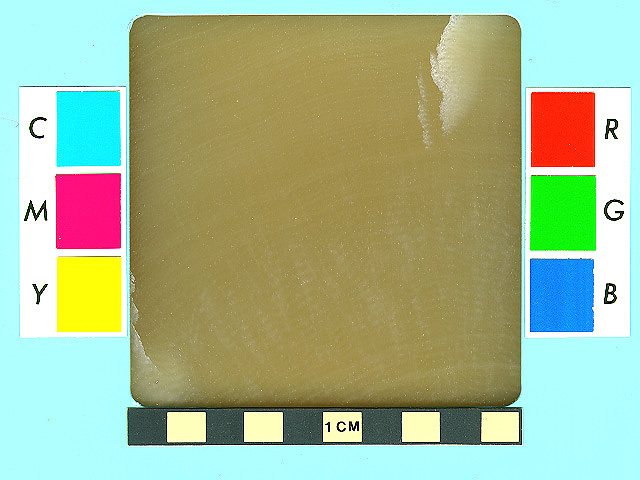
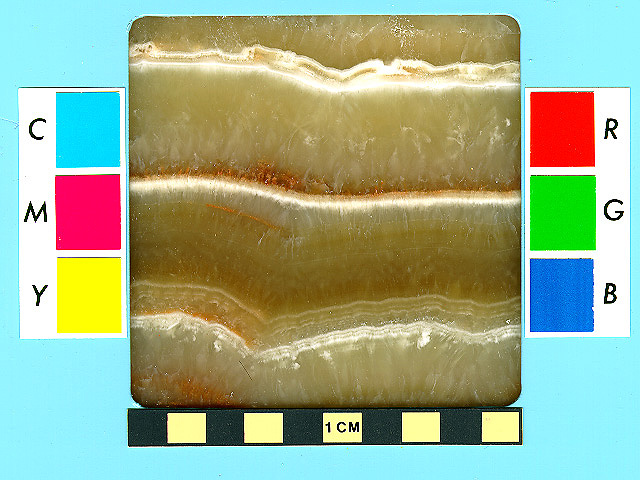
Travertine occurs as secondary veins and pods in the limestones of the Mokattam, Samalut, and Minia formations. All quarries are in the Eastern Desert and most are within 25 km of the Nile Valley. The ancient Egyptian name for travertine is Ss [shes] and, in the Old Kingdom, bit [bit]. The Romans called it lapis alabastrites and lapis onyx, and it was the alabastro cotognino [and venato], and alabastro [Egiziano or onice] of the Italian stonecutters. The ancient alabastrites (after the alabastron jars) is the origin of the petrologically incorrect name of "alabaster." Alabaster, as now defined by geologists, refers to a variety of rock gypsum.
General description: alternating bands of opaque white, fine-grained calcite and translucent, yellowish-brown, coarse-grained calcite, and occasionally massive amber-brown calcite [= calc-sinter travertine].
1. in Wadi Hof east of Helwan city [29o 52.06' N, 31o 26.21' E] (MK & NK?; medium)
2. in Wadi el-Garawi east of Helwan city [29o 48.32' N, 31o 27.99' E] (OK:4 & R?; large) PHOTO: sample 1
3. in Wadi Araba near Wadi Askhar el-Qibli [29o 4.78' N, 32o 3.10' E] (R; small) PHOTO: sample 1
4. in Wadi Umm Argub near Wadis Muwathil and Sannur [28o 38.10' N, 31o 16.03' E] (LP?; medium) PHOTO: sample 1 ; sample 2 ; sample 3
5. at el-Qawatir area opposite el-Minya city [28o 6.11' N, 30o 49.07' E] (OK/MK-NK & LP-R?; large)
6. in Wadi el-Barshawi near el-Bersha village [27o 42.37' N, 30o 56.16' E] (MK?; small)
7. in central Wadi el-Zebeida (a.k.a. Abd el-Azziz Quarry) north of el-Amarna ruins [27o 41.37' N, 30o 54.35' E] (MK?; medium)
8. east of Wadi el-Zebeida and northeast of el-Amarna ruins [27o 40.56' N, 30o 55.58' E] (NK:19; small)
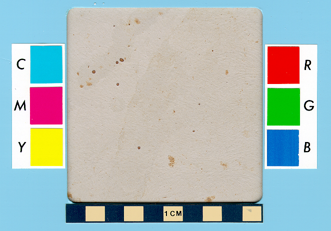
9. at Hatnub southeast of el-Amarna ruins [27o 33.30' N, 31o 1.39' E] (OK:4-6, MK:12, NK:18 & R; medium) PHOTO: sample 1
10. near Wadi Assiut [27o 18.93' N, 31o 21.56' E] (NK:18; small) PHOTO: sample 1
____________________ SANDSTONE ____________________
Sandstone was called inr HD nfr n (iner hedj nefer n rewdjet) or occasionally inr HD mnx n rwDt (iner hedj menech n rewdjet), both meaning “fine or excellent (nfr or mnx, respectively), light-colored (inr HD) hard stone (rwDt).” Although usually translated as “white,” here inr HD probably has a more general meaning of “light colored.” Sandstone is not normally considered a hard rock (rwDt), but it is often harder than limestone. In these names, the nfr or HD or even both were sometimes omitted, and the n was later dropped.
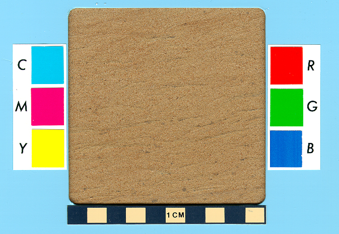
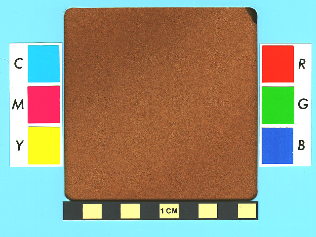
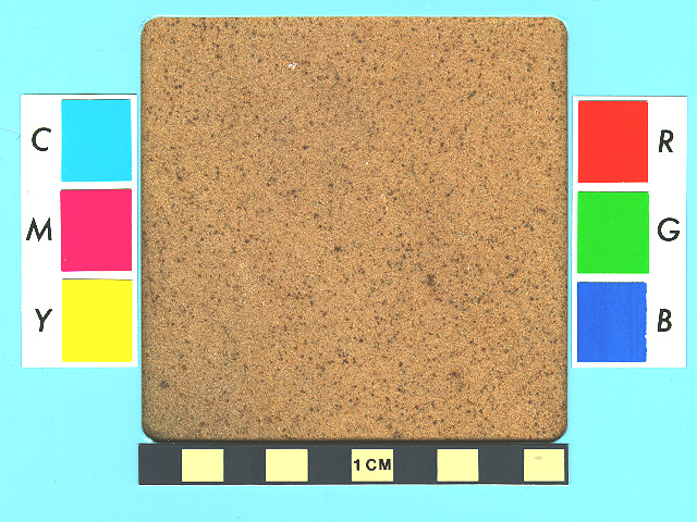
General description (based on quarry samples): brownish, highly porous, subarkosic arenite to quartz arenite sandstone (with the former restricted to the finer grain sizes). This friable rock is loosely cemented with quartz, iron oxides (goethite and minor hematite) and chlorite clay plus minor amounts of kaolinite clay and calcite.
All rock formations belong to the Nubia Group and, with the exception of the Duwi Formation, are together informally referred to as the Nubian Sandstone.
NILE VALLEY
Duwi Formation (Upper Cretaceous, Late Campanian to Early Maastrichtian stages): very fine- to medium-grained sandstone with mainly massive to planar bedding and occasional tabular cross-bedding.
1. at el-Mahamid village northwest of el-Kab ruins, East Bank [25o 8.15’ N, 32o 46.92’ E] (MK? & Pt; medium) PHOTO: sample 1 ; sample 2
2. at Shesmetet temple in Wadi Hilal northeast of el-Kab ruins, East Bank [25o 8.07’ N, 32o 49.03’ E] (NK:19 & Pt; small)
3. in Wadi Tarifa southwest of Hierakonpolis ruins, West Bank—completely destroyed [25o 4.70’ N, 32o 44.62’ E] (NK-R; medium)
4. southeast of el-Keijal village, East Bank [25o 4.09’ N, 32o 51.78’ E] (Pt or R?; small)
Quseir Formation (Upper Cretaceous, Early to Late Campanian stage): very fine- to mainly fine- to medium-grained sandstone with mostly tabular cross-bedding and occasional planar bedding.
5. at Nag el-Dumariyya village, East Bank [25o 2.96’ N, 32o 53.33’ E] (Pt-R; small)
6. below el-Bueib ruins on Gebel el-Sirag, East Bank—partially destroyed [24o 48.61’ N, 32o 54.84’ E] (MK-NK:18; medium)
7. south of Nag el-Raqiein village, West Bank [24o 44.76’ N, 32o 55.24’ E] (NK or younger; small)
8. at Nag el-Hosh village, West Bank [24o 44.31’ N, 32o 55.28’ E] (Pt-R; medium)
9. in Wadi el-Shatt el-Rigal, West Bank [24o 41.11’ N, 32o 55.39’ E] (MK & NK:18?; medium)
10. north and south of Nag el-Hammam village, West Bank [24o 40.36’ N, 32o 55.47’ E] (MK-NK; medium)
11a. at Gebel el-Silsila, West Bank [24o 39.05’ N, 32o 55.75’ E] (MK-R; large) PHOTO: sample 1
11b. at Gebel el-Silsila, East Bank [24o 38.48’ N, 32o 56.04’ E] (MK-R; large) PHOTO: sample 1
Umm Barmil Formation (Upper Cretaceous, Santonian to Early Campanian stages): fine- to coarse-grained sandstone with planar to mainly tabular cross-bedding.
12. at Nag el-Falilih village in Gharb el-Gaafra district, East Bank [24o 20.04’ N, 32o 55.27’ E] (Pt & R?; medium)
13. south of Nag el-Sheikh Garad village in Gharb el-Gaafra district, East Bank—partially destroyed [24o 18.45’ N, 32o 54.72’ E] (Pt & R?; large)
14. at Gebel el-Hammam north of Khor Abu Subeira, East Bank—completely destroyed [near 24o 13.5’ N, 32o 52.5’ E] (NK:18; small?)
15. south of Nag el-Fuqani village in the Gharb Aswan district, West Bank [24o 12.24’ N, 32o 51.60’ E] (Pt; medium)
16. at Hagar el-Ghorab in the Gharb Aswan district, West Bank [24o 11.33’ N, 32o 51.79’ E] (Pt or R; small)
17. at Gebel el-Qurna (or Chikka) in the Gharb Aswan district, West Bank [24o 9.75’ N, 32o 52.10’ E] (Pt or R; medium)
Abu Aggag Formation (Upper Cretaceous, Turonian stage): mainly medium- to coarse- grained, often conglomeritic, sandstone with planar to mainly trough cross-bedding.
18. at Qubbet el-Hawa, West Bank [24o 6.11’ N, 32o 53.26’ E] (OK/MK?; small)
19. at St. Simeon Monastery, West Bank [24o 5.69’ N, 32o 52.55’ E] (MK or B?; small)
20. east and southeast of Aswan city, East Bank—mostly destroyed [24o 3.10’ N, 32o 53.36’ E] (NK &R in part; medium?)
21. near Dabod temple, West Bank—under Lake Nasser [approx. 23o 53.7’ N, 32o 51.7’ E] (Pt-R; small?)
22. west and south of Qertassi temple, West Bank—under Lake Nasser [approx. 23o 41.8’ N, 32o 53.4’ E] (Pt-R; large)
23. near Tafa temple, West Bank—under Lake Nasser [approx. 23o 38.2’ N, 32o 52.3’ E] (R; small or medium?)
24. at Kalabsha temple, West Bank—under Lake Nasser [approx. 23o 33.6’ N, 32o 51.8’ E] (Pt-R; small or medium?)
25. between Abu Hor and Merowa villages, West Bank—under Lake Nasser [approx. 23o 27.0’ N, 32o 54.0’ E] (Pt-R; small or medium?)
Sabaya Formation (Lower to Upper Cretaceous, Albian to Early Cenomanian stages) and Lake Nasser Formation (Lower Cretaceous, Aptian stage) undifferentiated: fine- to coarse-grained, occasionally conglomeritic, sandstone with both trough and tabular cross-bedding.
26. near Qurta temple, West Bank—under Lake Nasser [approx. 23o 6.6’ N, 32o 44.1’ E] (NK:18 & R; small or medium?)
27. near Agayba village in the Mitiq district, West Bank—under Lake Nasser [approx. 22o 51.0’ N, 32o 34.0’ E] (NK?; small?)
28. west of Tumas village, West Bank—under Lake Nasser [approx. 22o 45.4’ N, 32o 7.0’ E] (NK:18-19; small or medium?)
29. below and north of Qasr Ibrim ruins, East Bank [approx. 22o 39.0’ N, 31o 59.5’ E] (NK-R?; small?)
30. at Nag Deira village in Tuskha East district, East Bank [approx. 22o 30.4’ N, 31o 53.5’ E] (NK?; small)
Abu Simbel Formation (Upper Jurassic to Lower Cretaceous, Neocomian to Barremian stages): a sandstone of uncertain character but probably similar to the Sabaya/Lake Nasser formations.
31. west of Gezira Dabarosa island, West Bank, Sudan—under Lake Nasser [approx. 21o 55.8’ N, 31o 18.7’ E] (age?; small)
32. west of Abdel Kadir village on 'Hieroglyph Hill', West Bank, Sudan [21o 52.41’ N, 31o 9.13’ E] (MK; small)
Eastern
Desert (Nubia Group
undifferentiated)
33. west of Krokodilô praesidium in Wadi el-Muweih on Qift-Quseir Road [25o 56.70’ N, 33o 23.91’ E] (R; medium)
34. southwest of Bir el-Kanayis temple and Hydreuma to epi tou Paneiou
praesidium in Wadi el-Kanayis on Edfu-Marsa Alum Road [25o
0.24’ N, 33o 18.52’ E] (NK:19 & R;
small)
Western Desert (Nubia Group undifferentiated)
35. at Qaret el-Farangi hill in Bahariya Oasis [28o 20.69’ N, 28o 51.92’ E] (LP26? or Pt-R?; small?)
36. at el-Muzawqa tombs near el-Qasr village in Dakhla Oasis [25o 40.91’ N, 28o 50.31’ E] (Pt or R?; small)
37. near Ain Umm Dabadid in northern Kharga Oasis [approx. 25o 46.1’ N, 30o 24.3’ E] (Pt-R?; small?)
38. on Gebel el-Teir in Kharga Oasis [approx. 25o 32.4’ N, 30o 33.0’ E] (LP26-R?; small?)
________________ OTHER SOFT STONES
_________________
Gypsum and Related
1. at Umm el-Sawan, northeastern Faiyum Desert [29o 42.47' N, 30o 53.06' E] (ED?, OK:3-4 & possibly R; large). Rock gypsum: veins of opaque white alabasterine gypsum with brownish to dark gray streaks; and of colorless selenite gypsum (the formet variety of gypsum is the true "alabaster"; in the past, this name has been incorrectly applied to Egyptian travertine) [Qasr el-Sagha Formation, Late Eocene]. PHOTO: sample 1
2. northeast of Qasr el-Sagha temple and northwest of Deir Abu Lifa hermitage in northern Faiyum Desert [29o 36.72’ N, 30o 40.84’ E] (ED or OK?; small?). Rock gypsum: veins of colorless to white, satin spar gypsum [Qasr el-Sagha Formation, Late Eocene ]
3. between Wadi el-Imrani and Wadi Ibada near el-Amarna, Nile Valley [thousands of pits between latitudes 27o 40.6' and 27o 49.3' N] (OK & NK:18; large). Gypsiferous soil (gypsite) on top of the limestone plateau: white, soft powdery and lumpy mixture of efflorescent gypsum and decomposed limestone plus minor secondary anhydrite and bassanite [Recent]
4. near Wadi el-Anba'ut, Eastern Desert on the Red Sea coast [24o 55.81' N, 34o 55.41' E] (early R; small). Rock gypsum and anhydrite: beds of opaque white to pinkish anhydrite and alabasterine gypsum [Abu Dabbab Formation, Miocene]
5. on Ras Banas peninsula, Eastern Desert on the Red Sea coast [23o 55.79' N, 35o 36.53' E] (Pt-R; medium). Rock gypsum and anhydrite: massive white anhydrite and alabasterine gypsum [Abu Dabbab Formation, Miocene]
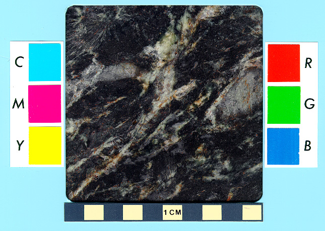
Steatite and Related
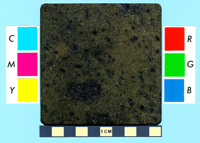
6. in Wadi Saqiyah near Wadi Semna, Eastern Desert [two sites: 26o 19.87' N, 33o 39.44' E in the north; and 26o 19.56' N, 33o 39.33' E in the south] (R: 1st c.AD; small). Talc schist: grayish-green [Precambrian basement]
7. in Wadi Abu Muawad (at Abu Muawad I gold mine) [25o 18.73' N, 33o 40.40' E] (R; small). Talc schist: greenish-gray [Precambrian basement]
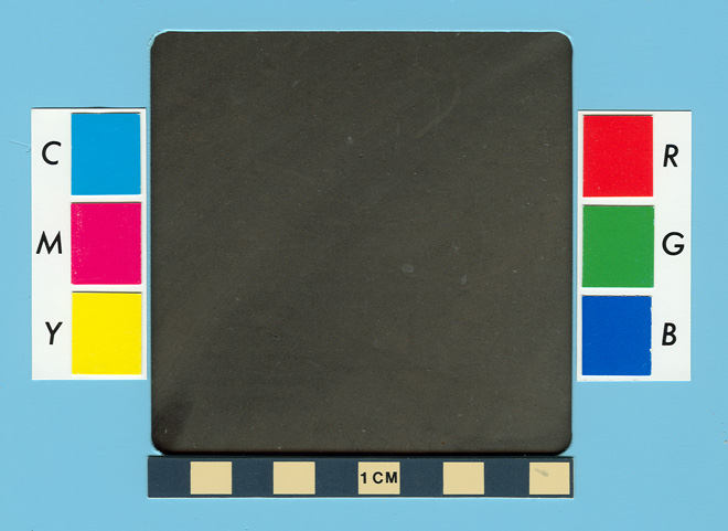
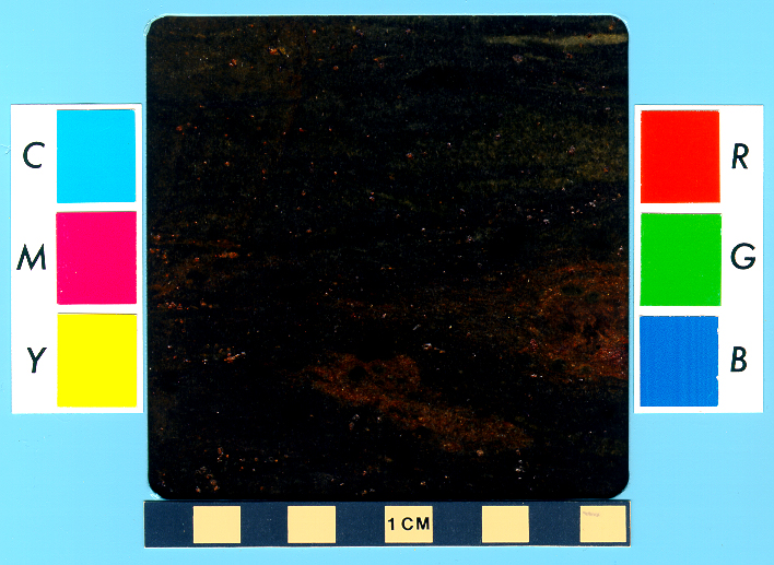
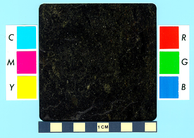
8. near Wadi Mubarak, Eastern Desert [25o 16.14' N, 34o 26.24' E] (LP:26 & late R-early Is; large). Steatite: dark grayish green, medium-grained [Precambrian basement] PHOTO: sample 1
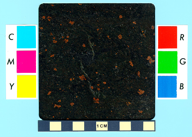
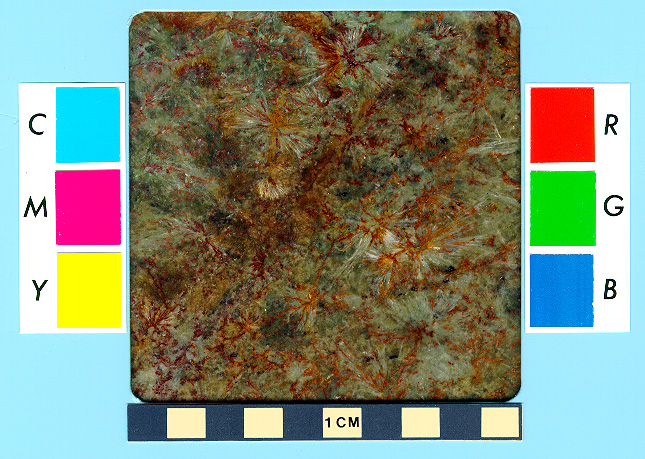
9. in and near Wadi el-Humra [25o 14.40' N, 33o 58.20' E in the west to 25o 13.30' N, 34o 0.20' E in the east] (Is: unknown c.; large). Steatite: light to dark green or mottled green and orange, fine- to coarse-grained [Precambrian basement] PHOTOS: sample 1 ; sample 2
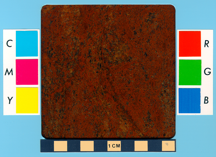
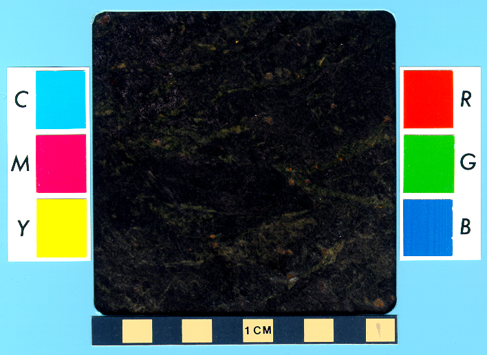
10. near Wadi Abu Qureya, Eastern Desert [25o 13.95' N, 34o 2.75' E] (R ?, Is: unknown c.; large). Steatite: dark greenish gray or mottled green and orange, fine-grained [Precambrian basement] PHOTOs: sample 1 ; sample 2 ; sample 3 ; sample 4
11. in Wadi Umm Salim, Eastern Desert [25o 7.77' N, 34o 0.50' E] (Is: unknown c.; medium). Steatite: grayish green, fine- to medium-grained [Precambrian basement]
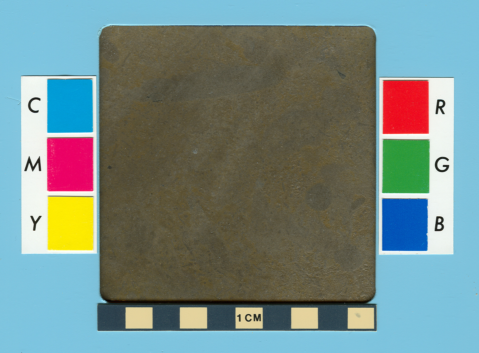
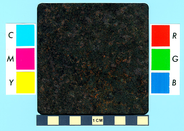
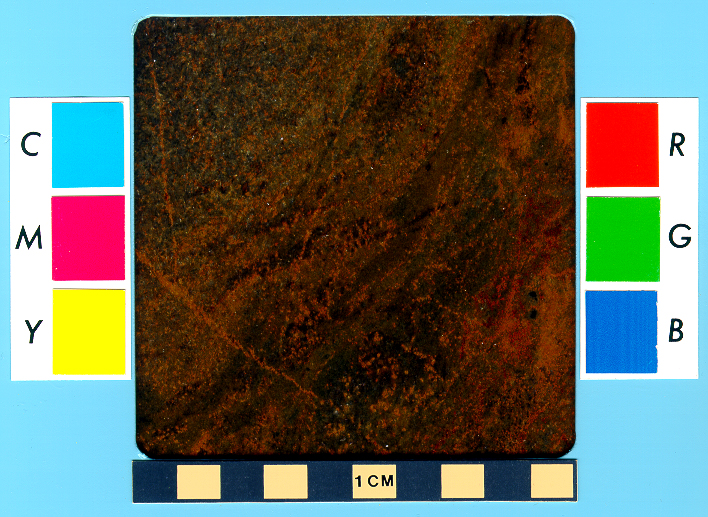
12. at Gebel Rod el-Barram, Eastern Desert [25o 6.15' N, 34o 4.37' E] (late R-early Is; large). Three varieties of steatite (soapstone) [Precambrian basement]: (a) dark gray, graphitic [PHOTO: sample 1]; (b) brownish green, coarse-grained and fibrous (actinolite-tremolite) [PHOTO: sample 1]; and (c) mottled medium and dark grayish green, fine-grained [PHOTO: sample 1].
13. in Wadi Sikait [24o 38.35’ N, 34o 47.70’ E] (R; small)
14. in Wadi Kamoyid near Gebel Korab Kenzie [22o 36.00' N, 34o 58.60' E] (Is: unknown c.; medium). Steatite: grayish green, medium-grained [Precambrian basement]
Marble
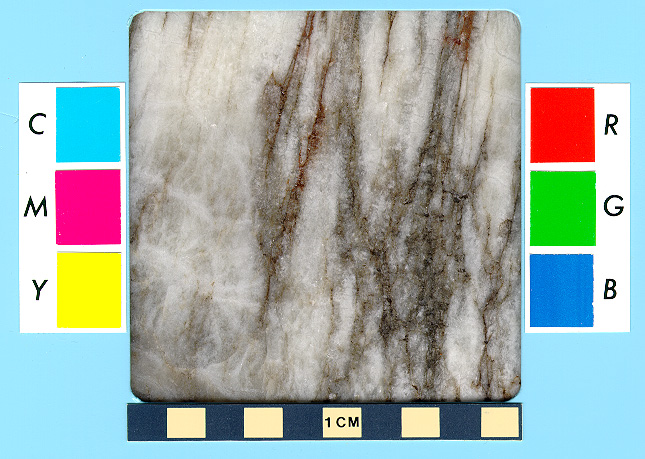
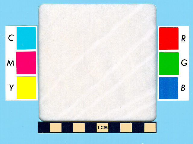
15. at Gebel Rokham near Wadi Miya, Eastern Desert - now destroyed [25o 17.98' N, 33o 57.94' E] (NK & Pt-R; small). Marble: variously colored and banded to mainly white, fine-grained; calcitic with minor brucite and dolomite [Precambrian basement]. PHOTO: sample 1
James A. Harrell
Professor Emeritus of Archaeological Geology
Department of Environmental Sciences
The University of Toledo